WaDL
WaDL
Contact
Light
Dark
Automatic
Projects
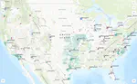
Development of nationwide water system boundary layer
Development of water service boundaries for 44,919 community water systems that deliver tap water to 306.88 million people in the US (97.22% of the population).
Github
Data
Writeup
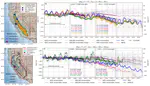
Remote Sensing-based Water Balance
Automated remote-sensing based software framework to assess groundwater changes
Paper
Github
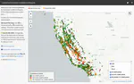
gsp dry wells .com
Domestic well failure prediction and cost estimates in critically overdrafted basins.
Project
Github
Paper
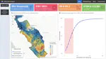
cal water quality .com
Automated water quality reports for > 3,000 California public water systems.
Code
Project
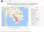
Near-Real-Time Satellite-Based Flood Monitoring System
Realtime Satellite-based flood monitoring and socioeconomic impact assessment system
Github
Methods Paper
Socioeconomic Paper
News
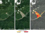
Satellite Landslide Identification Product (SLIP)
Automated remote sensing-based landslide identification product
Github
Paper
News
Patent
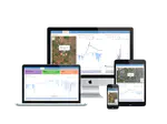
low cost sensor networks
Real-time sensor networks and dashboards for monitoring environmental data.
Github
Paper
Demo
Cite
×